Ancient Canal Du Midi Postcards and Photographs Narbonne to Sete.
Pictured below: Canal Du Midi in Narbonne.


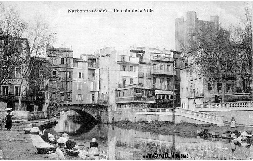
Pictured below: Canal De La Robine in Narbonne and the Pont des Marchands (bridge of the merchants). This bridge was part of the old Roman road from Italy to Spain, the Via Domitia. Part of this roman road can still be seen in front of the Narbonne Cathedral. It is also one of the few bridges left still inhabited. The bridge used to consist of 6 arches, but only one is visible these days. The remaining arches are in the basements of the neighboring houses. The Aude River used to flow here, but this river was diverted in the 14th century. Now the canal follows the old river bed. Locals used to wash their clothes in the canal, as can be seen in the ancient picture.

Pictured below: Canal De La Robine in Narbonne. The old picture shows the "bateau lavoir" or "washing boat." Richer residents could wash their clothes here in comfort, without having to kneel down next to the canal. This boat sunk in 1935 and in the process drowned its owner. Rumor had it that the owner was murdered. He had sold the boat a few days before and was paid in cash, but the cash was never found after his drowning. Around 1930, the parking deck visible in the new picture was constructed, and at the time it was a laundry facility that replaced the "bateau lavoir." The large square building in the center of the picture was a mill back in the day, but today it is the Narbonne tourist office.


Pictured below: Canal De La Robine in Narbonne.


Pictured below: Canal De La Robine in Narbonne. Up to 2012 there still used to be a foot bridge here. In recent years the city has spend great efforts to to clean up this area, and now it is a pleasant part of town to visit.


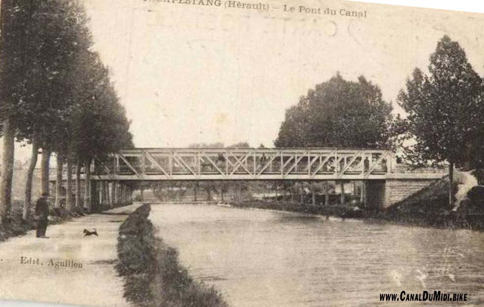
Pictured below: Canal Du Midi in Capestang. This railroad bridge is now used only by cars and bicycles. The track north of here has been converted to a bike path going to Cruzy.

Pictured below: Canal Du Midi aqueduct in Beziers, crossing the Orb River. This 240 meter long structure was put into service in 1858. It allowed canal traffic to avoid having to take the Orb River to rejoin the ancient Canal Du Midi a bit downstream from here. The Orb River was problematic due to its irregular flow. Port Neuf, located a few meters downstream from the aqueduct, dates from the same time.
.jpg)

Pictured below: Canal Du Midi aqueduct in Beziers.


Pictured below: Canal Du Midi

Pictured below: Canal Du Midi

Pictured below: Canal Du Midi

Pictured below: Canal Du Midi in Beziers. Epanchoirs du Trianon at the Ecluse d'Arièges. The highway A9 was build during the 1960's and it can be seen crossing the canal in the new picture. Also notice the size of the trees in the old photo (taken around 1900). They are the same size as the newly planted trees right now elsewhere along the canal! The lock-keeper's house had its roof raised a bit, which is why it is not lining up in the photos anymore.
.jpg)
.jpg)
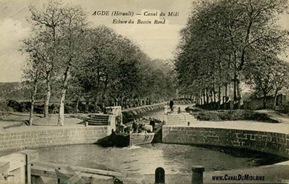
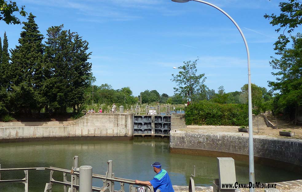
Pictured below: Canal Du Midi in Agde. The round lock. The lock was enlarged in 1978 to allow larger boats to pass into the Canal Du Midi. Thus one side of the lock bassin is larger now, as can be seen in the photos below.
Pictured below: Fort Saint-Pierre in Sete. Following the invasion by the British in 1710, a series of fortifications were built to protect the city, and this fort was built in 1743-1746 on the tip of the cape overlooking the cliffs. It was heavily damaged during WW2 and reconstructed in the 1960's. These days this is a open air amphitheatre over looking the sea (Théâtre de la Mer Jean Vilar). It is well worth a visit during the summer to catch a show.


Pictured below: Canal Du Midi in Sete.


Pictured below: The 650 meter long jetty Mole Saint Louis, the first structure built during the founding of the city in 1666. This jetty offers a seaside walk to the Saint-Louis Lighthouse located at its end. The lighthouse dates from 1861, but was demolished during the second world war. In 1948 it was rebuilt. One can climb its 116 steps to the top. The smaller lighthouse, only visible in the old picture, dates from 1721. It too was destroyed on August 19, 1944. (source)


Pictured below: Canal Du Midi, Sete. Until the 17th century, the sea came up as far as the Pont de la Savonnerie bridge. After the Sete Canal was dug and maritime trade expanded, dwellings and warehouses were built on the ground floor, now home to a number of restaurants. On the Quai General Durand, also knows as Quai de la Marine, a double flight of steps (the 'escalier de la Macaronade') still leads up to the Grand Rue Haute and the Quartier Haut (Upper District) and the church of Saint-Louis. The late 19th century was the golden age of the port. Sete became the world's leading port for wine and barrel-making. It landed wines from North Africa as well as cod caught in Newfoundland and oranges from the Balearics. Today harbour activity is still at the heart of the town, with all the comings and goings of the trawlers that go out every day to fish at sea. The larger boats only go out once a year though, around May.

